VicinityและPromontoryคดีพระวิหารปี2505

คำว่า"Vicinity"และ"Promontory"ในคำพิพากษาคดีปราสาทพระวิหารปี 2505
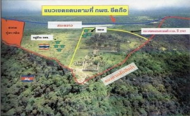
การปรากฏตัวของคำว่า “vicinity” และ “promontory” ในคำพิพากษาศาลโลก (ICJ) “คดีปราสาทพระวิหารในปี พ.ศ.2503-2505/ค.ศ.1959-1962” และ “คดีตีความคำพิพากษาฯ พ.ศ.2554-2556/ค.ศ.2011-2013” จากเอกสารคำพิพากษาคดีปราสาทพระวิหาร พ.ศ.2505/ค.ศ.1962 ฉบับภาษาอังกฤษที่ชื่อว่า “Report of Judgments, Advisory Opinions and Orders: Case Concerning the Temple of Preah Vihear (Cambodia v. Thailand) Merits” ในส่วนเนื้อหาของคดี (merits) และฉบับภาษาไทย “คำพิพากษาศาลยุติธรรมระหว่างประเทศ คดีปราสาทพระวิหาร จัดพิมพ์โดย สำนักทำเนียบนายกรัฐมนตรี แปลโดย กระทรวงการต่างประเทศ” ซึ่งมีคำพิพากษาเมื่อวันที่ 15 มิถุนายน พ.ศ.2505/ค.ศ.1962 มีดังนี้
1. คำว่า “vicinity” จำนวนทั้งสิ้นเพียง 3 ครั้ง เท่านั้น ได้แก่
1.1“the true watershed line in this vicinity” (หน้า 21)
“เส้นสันปันน้ำอันแท้จริงที่ปรากฏในบริเวณนั้น” (หน้า 26-27)
1.2 “the true watershed line in this vicinity” (หน้า 33)
“เส้นสันปันน้ำที่แท้จริงในบริเวณใกล้เคียงนี้” (หน้า 50)
1.3 “in its vicinity on Cambodian territory” (หน้า 37)
“ในบริเวณใกล้เคียงบนอาณาเขตของกัมพูชา” (หน้า 51)
2. คำว่า “promontory” จำนวนทั้งสิ้นเพียง 3 ครั้ง เท่านั้น ได้แก่
2.1 “It stands on a promontory of the same name” (หน้า 15)
“ปราสาทแห่งนี้ตั้งอยู่บนยอดเขาที่มีชื่อเดียวกัน” (หน้า 17)
2.2 “the whole Preah Vihear promontory” (หน้า 21)
“บริเวณพระวิหารทั้งหมด” (หน้า 26)
2.3 “the whole Preah Vihear promontory.” (หน้า 26)
“บริเวณชะโงกผา ณ พระวิหาร” (หน้า 35)
ดังนั้น จากคำและข้อความดังที่ได้ยกตัวอย่างมา เราจะพบว่ามีการแปลคำว่า “vicinity” และ “promontory” แตกต่างกัน ดังนี้
vicinity คำที่ 1 แปลว่าบริเวณ
vicinity คำที่ 2 แปลว่าบริเวณใกล้เคียง
vicinity คำที่ 3 แปลว่าบริเวณใกล้เคียง
promontory คำที่ 1 แปลว่ายอดเขา
promontory คำที่ 2 แปลว่าบริเวณ
promontory คำที่ 3 แปลว่าบริเวณชะโงกผา
ซึ่งหากอ่านคำพิพากษาของศาลโลก เมื่อปี พ.ศ.2505/ค.ศ.1962 เราจะพบว่า ศาลอธิบายคำว่า “promontory” เอาไว้ค่อนข้างชัดเจนแล้วว่า คือ
1.1 “It stands on a promontory of the same name, belonging to the eastern sector of the Dangrek range of mountains which, in a general way, constitutes the boundary between the two countries in this region – Cambodia to the south and Thailand to the north. Considerable portions of this range consist of a high cliff-like escarpment rising abruptly above the Cambodian plain. This is the situation at Preah Vihear itself, where the main Temple buildings stand in the apex of a triangular piece of high ground jutting out into the plain. From the edge of the escarpment, the general inclination of the ground in the northerly directions is downwards to the Nam Moun river, which is in Thailand.
It will be apparent from the description just given that a frontier line which ran along the edge of the escarpment, or which at any rate ran to the south and east of the Temple area, would leave this area in Thailand; whereas a line running to the north, or to the north and west, would place it in Cambodia.
Thailand has urged that the edge of this escarpment constitutes the natural and obvious line for a frontier in this region. In support of this view Thailand has referred to the documentary evidence indicative of the desire of the Parties to establish frontiers which would not only be "natural", but visible and unmistakable-such as rivers, mountain ranges, and hence escarpments, where they exist .
The desire of the Parties for a natural and visible frontier could have been met by almost any line which followed a recognizable course along the main chain of the Dangrek range. It could have been a crest line, a watershed line or an escarpment line (where an escarpment existed, which was far from always being the case). As will be seen presently, the Parties provided for a watershed line. In so doing, they must be presumed to have realized that such a line would not necessarily, in any particular locality, be the same line as the line of the crest or escarpment. They cannot therefore be presumed to have intended that, wherever an escarpment existed, the frontier must lie along it, irrespective of all other considerations.” (หน้า 15)
“ปราสาทแห่งนี้ตั้งอยู่บนยอดเขาที่มีชื่อเดียวกัน อันประกอบเป็นส่วนตะวันออกของทิวเขาดงรัก ซึ่งกล่าวโดยทั่วไปแล้วเป็นเขตแดนระหว่างประเทศทั้งสอง ในบริเวณนี้ กล่าวคือ ประเทศกัมพูชาอยู่ทางด้านใต้ และประเทศไทยทางด้านเหนือ ส่วนใหญ่ของทิวเขานี้ประกอบด้วยหน้าผาสูงตั้งชันขึ้นไปจากที่ราบของกัมพูชา เขาพระวิหารเองก็มีลักษณะเช่นนี้ ส่วนก่อสร้างที่สำคัญของปราสาทพระวิหารตั้งอยู่บนยอดของพื้นที่สูงรูปสามเหลี่ยมซึ่งชะโงกออกไปเหนือที่ราบเบื้องล่าง จากขอบหน้าผาพื้นที่โดยทั่วไปเทต่ำลงทางด้านเหนือไปทางแม่น้ำมูลซึ่งอยู่ในเขตไทย
จากคำบรรยายข้างต้นจะเห็นได้ว่าเส้นเขตแดนซึ่งเลาะตามขอบหน้าผา หรืออย่างน้อยที่แล่นไปทางทิศใต้และทิศตะวันออกของบริเวณปราสาทจะมีผลให้พื้นที่บริเวณนี้อยู่ในเขตไทย ส่วนเส้นเขตแดนที่ลากไปทางทิศเหนือและทิศตะวันตก จะทำให้พื้นที่บริเวณนี้ตกอยู่ในเขตกัมพูชา
ประเทศไทยได้อ้างว่าหน้าผานี้เป็นเส้นเขตแดนที่เป็นไปตามธรรมชาติของภูมิภาคนี้และสามารถเห็นได้ชัด เพื่อสนับสนุนข้ออ้างนี้ประเทศไทยได้อ้างพยานเอกสารซึ่งแสดงให้เห็นความประสงค์ของคู่กรณีที่จะสถาปนาเขตแดนซึ่งมิใช่แต่เพียงให้เป็นไปตาม “ธรรมชาติ” เท่านั้น หากแต่จะต้องเป็นที่มองเห็นได้ง่ายโดยไม่ผิดพลาด ดังเช่น แม่น้ำ ทิวเขา และชะง่อนหน้าผาตามที่เป็นอยู่โดยธรรมชาติ
ความประสงค์ของคู่กรณีที่จะให้มีเส้นเขตแดนที่เป็นธรรมชาติและเห็นได้ง่าย อาจจะกระทำได้โดยเลือกถือเอาเส้นใดเส้นหนึ่งที่มองเห็นเป็นแนวเส้นได้ชัดเจนตามทิวเขาใหญ่ๆ ในหมู่เขาดงรัก เส้นนั้นอาจเป็นเส้นสันเขา เส้นสันปันน้ำ หรือชะง่อนหน้าผา (ในที่ซึ่งมีชะง่อนหน้าผาอยู่ แต่ปกติมักจะไม่เป็นเช่นนั้น) ดังจะได้เห็นต่อไปว่า คู่กรณีได้ตกลงที่จะถือตามเส้นสันปันน้ำ ในการทำเช่นนี้จะต้องสันนิษฐานว่าคู่กรณีได้ทราบดีแล้วว่า ในท้องถิ่นบางแห่ง เส้นสันปันน้ำนี้ไม่จำเป็นที่จะต้องเป็นเส้นเดียวกับเส้นสันเขาหรือชะง่อนหน้าผา ดังนั้น จึงไม่ควรสันนิษฐานว่าคู่คดีเจตนาที่จะถือว่าที่ใดมีชะง่อนหน้าผา เขตแดนจะต้องเป็นไปตามชะง่อนหน้าผานั้นโดยไม่คำนึงถึงข้อพิจารณาอื่นๆ ทั้งสิ้น” (หน้า 17-18)
2.2 “Amongst these was one of that part of the Dangrek range in which the Temple is situated, and on it was traced a frontier line purporting to be the outcome of the work of delimitation and showing the whole Preah Vihear promontory, with the Temple area, as being on the Cambodian side.” (หน้า 20-21)
“ในบรรดาแผนที่อื่นๆ เหล่านี้ มีฉบับหนึ่งซึ่งเกี่ยวกับทิวเขาดงรักตอนที่พระวิหารตั้งอยู่ และบนแผนที่ฉบับนี้มีเส้นเขตแดนซึ่งดูเสมือนว่าเป็นผลจากการกำหนดเส้นเขตแดนและซึ่งแสดงว่าบริเวณพระวิหารทั้งหมดรวมทั้งเขตปราสาทอยู่ทางด้านกัมพูชา” (หน้า 26)
2.3 “If, as Thailand has argued, the geographical configuration of the place is such as to make it obvious to anyone who has been there that the watershed must lie along the line of the escarpment (a fact which, if true, must have been no less evident in 1908), then the map made it quite plain that the Annex 1 line did not follow the escarpment in this region since it was plainly drawn appreciably to the north of the whole Preah Vihear promontory.” (หน้า 26)
“ถ้าหากว่าลักษณะสัณฐานภูมิศาสตร์ของพื้นที่นี้ที่เห็นได้ชัดแก่ทุกคนที่เคยไปยังที่นั้นว่าสันปันน้ำเป็นไปตามเส้นขอบหน้าผาดังที่ประเทศไทยได้กล่าวอ้างแล้ว (ข้อเท็จจริงซึ่งถ้าเป็นความจริงย่อมต้องเห็นได้ชัดเช่นกันใน ค.ศ.๑๙๐๘) แผนที่ฉบับนี้ก็ได้แสดงไว้อย่างชัดเจนว่า เส้นเขตแดนตามภาคผนวก ๑ ในอาณาบริเวณนี้มิอาจได้เป็นไปตามขอบหน้าผา แต่กลับหันเหขึ้นไปทางเหนือของบริเวณชะโงกผา ณ พระวิหารอย่างเห็นได้ชัด” (หน้า 35)
โดยสรุป จากเอกสารคำพิพากษาคดีตีความฯ เมื่อวันที่ 11 พฤศจิกายน พ.ศ.2556/ค.ศ.2013 ศาลก็เพียงแต่ได้ยืนยันตามคำพิพากษาเดิมเมื่อปี พ.ศ.2505/ค.ศ.1962 เท่านั้น.


